Two-Dimensional software is transforming how drainage professionals analyze watersheds for airport drainage master plan studies, offering improved accuracy, time and cost efficiency, more effective communication, and the ability to reuse the model as an asset for future projects.

In current day drainage analysis, technology has forever changed how we approach identification of flood hazards and delivery of effective solutions to our clients. One such technology that has gained traction in recent years is two-dimensional modeling to evaluate both watershed runoff estimation (hydrology) and flow rate specifics such as water-surface elevations and velocities (hydraulics). Specifically, FLO-2D is a powerful software that is transforming the way drainage professional analyze watersheds for many large- and small-scale projects, including airport drainage master plan (DMP) studies.
Traditional DMP Approach
Traditional methodologies performed for airport DMPs involved the use of conservative assumptions and simplified equations to estimate runoff flow rates. They also required separate software packages to evaluate various hydraulic infrastructure such as culverts, storm drains, and retention basins. Keeping track of the combined downstream flow rates can sometimes require a number of assumptions and simplifications, often resulting in overly-conservative flows and ultimately inflated infrastructure costs. Development of Rational Method hydrologic models is time-consuming and labor-intensive. It provides conservative results typically due to the inability to account for varying travel times, flow attenuation, and storage that happens throughout the developed watershed. However, with the introduction of a powerful new software, FLO-2D, engineers can now quickly and accurately predict and visualize the results of every design storm event for every square foot of space within the entire airport, making it an invaluable tool for both planning and design.
Improved Accuracy
One of the most significant benefits of using FLO-2D is that it can calculate and extract data on demand at all locations within the model domain boundary. Unlike the Rational Method that produces only a single flow rate at a given catchment outfall location, FLO-2D performs both hydrology and hydraulics within the same model. This results in more accurate flow rates and hydraulic estimates than traditional methods. With FLO-2D, there is less room for human error and engineers can obtain a more sophisticated analysis of the study area. Another important benefit with this model is the unique ability to visually review the results and then make calibration adjustments to both infiltration and surface flow parameters for validation purposes.
Time and Cost Efficiency
Although FLO-2D produces more accurate runoff estimates in both natural and urban environments the engineer’s level of effort for model setup and review is typically not significantly different than with traditional methods. As a result, the cost to the client is comparable to traditional methods. In fact, it often times becomes a more cost-effective approach; FLO-2D models can extract results more efficiently, allowing engineers to focus their efforts on other aspects of the project such as flood hazard identification, infrastructure assessments, and alternatives analysis. Once the model is set up with all existing condition features, flood hazards can be identified from the graphical model output data. Various design alternatives can also be evaluated for their anticipated benefits. By testing a variety of conceptual design solutions, engineers can identify the most preferrable solution in terms of cost and hydraulic efficiency to make informed decisions for the airport improvements.
More Effective Communication
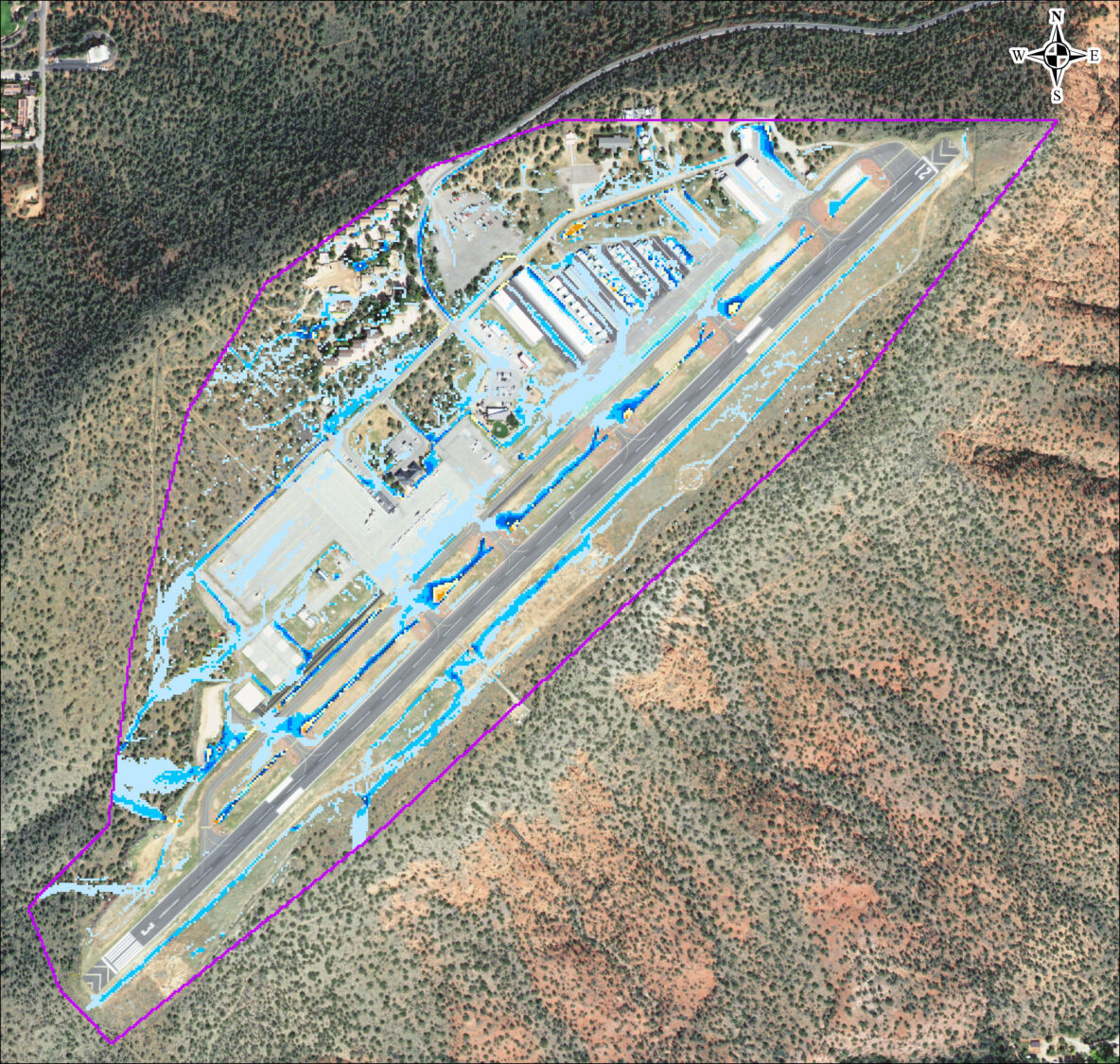
Another key advantage of FLO-2D is the ability to graphically illustrate the model results, a benefit to both the engineer and the end-user. Using external post-processing tools, model output files can be used to generate easy-to-understand visualizations of water rates, depths, velocities and other hydraulic parameters, making it an excellent communication tool for presenting findings to stakeholders who may not have technical expertise in drainage engineering. Traditional 1D methods produce only tables of output results, which is difficult for project partners to understand. However with FLO-2D, the graphical results are easy to understand. Airport managers, city officials, and even the general public can see an image like the one below and understand that the culvert crossing this taxiway is undersized for this design. Therefore, stormwater may be expected to overtop the paved surface.
By providing clear and concise data, FLO-2D can help ensure that all parties involved have a shared understanding of the project. This can ultimately lead to more informed decision-making and better solutions.

A Tool for the Future
Once the FLO-2D model is developed for an airport, it becomes an asset and a reusable tool that is easily updated as conditions change and new projects are constructed. Because the entire airport is analyzed within a single model, FLO-2D allows engineers to see the interrelated nature of drainage issues. Additionally, it demonstrations how design solutions can work together to solve these issues. FLO-2D is an ideal planning tool for understanding the drainage impacts of future projects and can help with cost/benefit analyses.
At EPS Group, our vision is Innovate to Elevate Lives. We embrace technology such as FLO-2D in support of this vision, because it helps us provide better solutions to our clients and ultimately makes our airports safer and more resilient.
Written By: Justin Beeler, PE, CFM
Senior Project Manager

Learn more about our Flood Control group’s capabilities and expertise for airport master planning.